Paula Scher’s maps tell truths about their maker
Poor little Utah. Well, poor not-so-little Utah. On the first map Paula Scher ever made of the United States—“The United States From Memory, by Hand”—she forgot Utah. Left it out. By the time that work had appeared as the back cover of the American Institute of Graphic Arts (AIGA) annual, she had remembered Utah, “so I put it in the water, with an arrow.” The Pacific water, that is.
Her much, much, much larger United States, 9-feet high by 12-feet wide, acrylic on canvas, in “The Maps,” Scher’s one-woman show at the Maya Stendhal Gallery, not only has Utah in the right place but in a rather brighter sand color that makes it stand out a bit from all the other 49 dark brown, dark blue, dark green, dark gray states.
Even people who’ve always loved maps, and you are reading one of them, have never seen anything like this exhibit—these maps. First of all, they’re big.
There’s Long Island, for instance, a cream-and-pink
7 1/2-foot lobster drowsing between a Long Island Sound and an inky Atlantic Ocean swirling with sea currents of hundreds, maybe thousands, of close-packed Long Island place names—Roslyn, Roslyn Heights, Plandome, Roslyn Estates, Seacliff…
There’s Africa in black, white, and gray, fewer place names but enough, and more magical.
There’s South America in five or six bolder, brighter colors. There’s an older, dingier, duller Europe. There’s Washington, D.C., a 5-foot cockeyed Scrabble board of, again, thickets of place names, street names, bridges, dead ends, avenues. There’s Greater Los Angeles, a candy-colored almost impenetrable web of streets, avenues, freeways, suburbs.
There’s a 10-foot asphalt-colored Manhattan, lying horizontally like a patient etherized upon a table, fed through the IV’s of 20 bridges and tunnels while bandaged all over, head to foot, by large white zip codes.
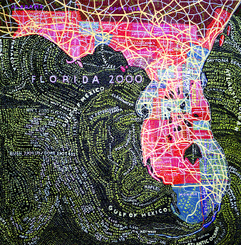
And there is also “Florida 2000,” red precincts and blue precincts, a sore thumb thrusting down between the Atlantic Ocean and the Gulf of Mexico. If you look close, you’ll spot some ballot counts swimming among all the place names.
“I can understand a place through color and words,” Scher said. “We all understand the world in a particular way whether we’ve been there or not. I was asked to do India, and India has a soul, so I did it. I was asked to do Nantucket, but I have no feeling for Nantucket at all.”
Scher, a blonde-helmeted handsome woman in her middle 50s, lives in Chelsea and is, in her own nonchalant words, “then and now a famous graphic designer—with a struggling business,” though the business is the no less prestigious Pentagram outfit on Lower Fifth Avenue, of which she’s a partner. One of the many end products of her work you may have seen without knowing it is the graphic accoutrement – programs, billboards, whatever—of the Joseph Papp Public Theater.
Design is Paula Scher’s vocation. Maps are her avocation.
“My father,” she disclosed, “was a mapmaker. There were maps all over the house when I was a little kid.”
Wouldn’t you know it.
Marvin Scher, who died a year and a half ago, worked with the United States Geological Survey as a photogrammatric engineer—“that’s somebody who measures light”—invented a measuring device called a stereo template, and helped develop aerial photography.
“He told me that maps always look like they’re telling the truth, but they aren’t,” Paula recalled. “They’re inaccurate. All maps lie.”
As a member herself of AIGA, she undertook, as a joke, to paint for the group a small (2-foot) map called “New York, New York, Actual Size.” It somehow got put up at auction “and somebody spent $1,000 for it. I was very impressed.”
A year and a half later, AIGA asked her to put her hand to the front and back covers of their annual.
“There would be no fee, but they would pay up to $1,000 expenses,” she said. “If you had no expenses, you got to keep the $1,000.”
She did a front cover dominated by a surreal eye, and, for the back cover, that “United States From Memory.”
It was habit-forming.
“I started painting these small, cute maps that Marvin and Ruth Sackner, collectors in Miami, liked,” she explained. “That went on for a period of time, until I got bored with the scale of them. I wondered what would happen if I went to very big scale. The small ones had been cute, acerbic, silly, full of snide comments. As they got bigger, they developed soul.”
Scher paints her very big maps in a very small room at the country house she and her husband, Seymour Chwat, an artist, have in Connecticut. Every so often Chwat wanders in to where she’s working, takes a look, and tells her she’s spelled this name or that name wrong.
“I say: ‘Too bad—that’s not the point of this painting,”’ she said.
In fact the thousands of names packed into her pictures get no proofreading at all.
The large map of the U.S.—the one “where I was nice to Utah” and put it back in the right place—took six months of three-day weekends to complete. The Maya Stendhal exhibit covers six years’ worth of work.
Scher’s maps “are really the opposite of what I do here” at Pentagram, where, though the actual design work “is intuitive and very fast,” most of her time, she explained, is spent “persuading committees and clients to make things—whereas with the maps I make anything I want.”
For all that, she became uncustomarily nervous when an artist friend, Jeff Scher (no relation), got gallery owner Maya Stendhal interested in Paula Scher’s maps.
“I was very afraid to show them,” Scher admitted.
But you don’t seem like a very afraid woman.
“Well, it’s very personal, and incredibly obsessive,” Paula Scher explained. “The maps are getting more and more insane. As a designer you’re expected to make things. This work is very private. I felt opening night I was walking around naked.”
The show at Maya Stendhal continues through December 17. You won’t fine Scher walking around naked—except, in a manner of speaking, on the walls.
gaycitynews.com